
Photo Agency - Astronomy - Space - Nature


> Earth from space gallerie
 |
 |
SlideShow Image 715 / 2740 |  |
 |
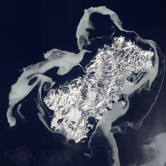
Shikotan island seen from space
auteur: Nasa/Novapix
référence: t-asrus-00016
Image Size 300 DPI: 31 * 31 cm
Ostrov Shikotan (or Shikotan-to) is a volcanic island at the southern end of the Kuril chain. Shikotan lies along the extreme southern edge of winter sea ice in the Northern Hemisphere. The Advanced Land Imager (ALI) on NASAâs Earth Observing-1 (EO-1) satellite captured this natural-color image of Shikotan on February 14, 2011. The island is surrounded by sea iceâswirling shapes of ghostly blue-gray. The ice in this image may have formed in a matter of several days, and it is prone to moving with currents. North of the western end of Shikotan, eddies have shaped the ice into rough circles. The eddies may result from opposing windsâwinds from the north pushing the ice southward, and winds from the southwest pushing the ice toward the northeast.
Part of the Pacific Ring of Fire, the island is seismically active.
Keywords for this photo:
2011 - ASIA - CLIMATE - EARTH - EARTH FROM SPACE - EO-1 - ICE - ISLAND - KURIL - PACIFIC RING OF FIRE - RUSSIA - SATELLITE IMAGE - SHIKOTAN - SNOW - WINTER -
Contact : Stéphane Aubin +33-(0)9-51-26-53-76
© Novapix - All rights reserved