
Photo Agency - Astronomy - Space - Nature


> Land surface temperatures in november 2007
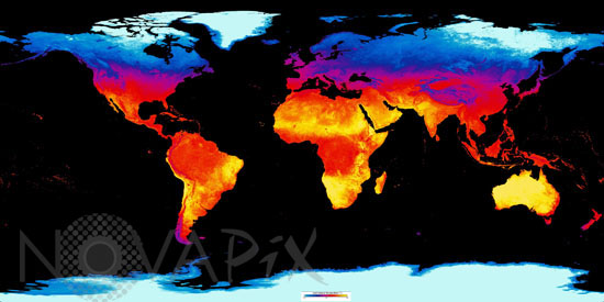
Land surface temperatures in november 2007
author: Nasa/Novapix
reference: t-glb50-00115
Image Size 300 DPI: 30 * 15 cm
This image shows daytime land surface temperature as observed by the Moderate Resolution Imaging Spectroradiometer (MODIS) flying on NASAâs Terra satellite between November 1 and December 1, 2007.
It shows how the indirectness of sunlight at high latitudes affects temperature. The coldest areas, colored blue and white, are in the north, while the warmest areas, yellow and red, are near the Equator. These are also the planetâs most snow-covered areas.
Keywords for this photo:
2007 - CLIMATE - EARTH - EARTH FROM SPACE - GLOBAL VIEW - MODIS - PLANET - PLANISPHERE - SATELLITE IMAGE - SOIL - TEMPERATURE - TERRA -
Contact : Stéphane Aubin +33-(0)9-51-26-53-76
© Novapix - All rights reserved