Photo Agency - Astronomy - Space - Nature

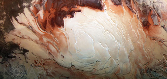
Mars South pole
author: ESA/DLR/FU Berlin-B.Dunford/Novapix
reference: a-mar09-00165
Image Size 300 DPI: 19 * 10 cm
The bright white region of this image shows the icy cap that covers Mars’ south pole, composed of frozen water and carbon dioxide. While it looks smooth in this image, at close quarters the cap is a layered mix of peaks, troughs and flat plains, and has been likened in appearance to swiss cheese.
The southern cap reaches some 3 km thick in places, and is around 350 km in diameter. This icy region is permanent; in the martian winter another, thinner ice cap forms over the top of it, stretching further out across the planet and disappearing again when the weather warms up.
The cap is around 150 km north of Mars’ geographical south pole and Mars Express has shed light on why this ice cap is displaced. Deep impact craters – notably the Hellas Basin, the largest impact structure on the entire planet at 7 km deep and 2300 km across – funnel the strong winds that blow across Mars towards its southern pole, creating a mix of different low- and high-pressure systems. The carbon dioxide in the polar cap sublimates at different rates in these regions with contrasting pressure, resulting in the cap’s lopsided structure.
Mars Express imaged this area of Mars on 17 December 2012, in infrared, green and blue light, using its High Resolution Stereo Camera.
Keywords for this photo:
2012 - ASTRONOMY - ICE - MARS - MARS EXPRESS - PLANET - POLE - SOUTH POLE -
Contact : Stéphane Aubin +33-(0)9-51-26-53-76
© Novapix - All rights reserved


