
Photo Agency - Astronomy - Space - Nature


> Io cylindrical map
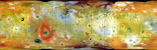
Io cylindrical map
author: Nasa/JPL/Novapix
reference: a-jup05-00205
Image Size 300 DPI: 19 * 6 cm
This false color infrared composite of Jupiter's moon Io was produced from images acquired in July and September, 1996, during the first two orbits through the Jovian system by NASA's Galileo spacecraft. The area shown is 11,420 kilometers in width. Grid lines in this cylindrical map projection are superimposed at latitude and longitude intervals of 30 degrees. Deposits of sulfur dioxide frost appear in white and grey hues while yellowish and brownish hues are probably due to other sulfurous materials. Bright red materials (such as the prominent ring surrounding the currently erupting plume Pele) and spots with low brightness or albedo ("black" spots) mark areas of recent volcanic activity and are usually associated with high temperatures and surface changes (Voyager to Galileo or Galileo to Galileo). The color in the image is composed of data taken in the near-infrared (756 nanometer), green and violet filters (shown as red, green, and blue respectively) of the Solid State Imaging (CCD) system aboard NASA's Galileo spacecraft. Images were obtained at resolutions ranging from 10 to 23 kilometers per picture element (pixel) and phase angles (spacecraft-Io-sun angle) from 4 to 55 degrees. The spacecraft range varied from 485,000 to 2,243,000 kilometers. North is to the top of the picture.
Keywords for this photo:
1999 - ASTRONOMY - FALSE COLOR - GALILEAN SATELLITE - GALILEO - GLOBAL VIEW - IO - JOVIAN MOON - PLANISPHERE - SATELLITE -
Contact : Stéphane Aubin +33-(0)9-51-26-53-76
© Novapix - All rights reserved