Photo Agency - Astronomy - Space - Nature

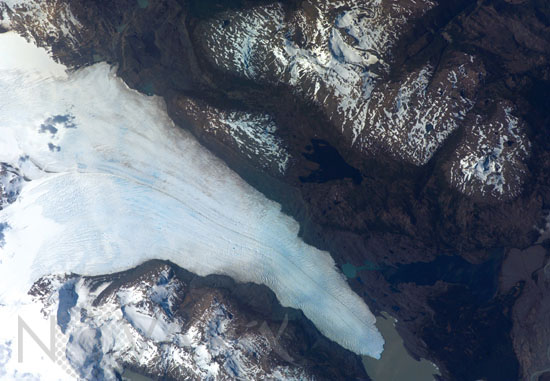
Tyndall Glacier, Chile
author: Nasa/Novapix
reference: t-sachi-00007
Image Size 300 DPI: 24 * 17 cm
Tyndall Glacier is located in the Torres del Paine National Park in Chile. This glacier, which has a total area of 331 square kilometers and a length of 32 kilometers (based on 1996 measurements), begins in the Patagonian Andes Mountains to the west and terminates in Lago Geikie. The digital astronaut photograph taken in november 2007 records visible light in red, green, and blue wavelengths (true color). The Tyndall Glacier terminus has retreated significantly during the past 17 years. Significant ice loss was also observed earlier this year at Grey Glacier, about 30 kilometers to the north-northeast, suggesting both glaciers are responding similarly to regional changes in temperature and precipitation. A medial moraine is visible in the center of the glacier, extending along its length (top image, center left). Moraines accumulations of soil and rock debris form along the edges of a glacier as it flows downhill across the landscape (much like a snowplow builds ridges of snow along the roadside). Glaciers flowing downslope through adjacent valleys merge when they encounter each other, and debris entrained along their sides becomes concentrated in the central portion of the new combined ice mass, much as small streams join to form a river.Crevasse fields are also visible in the image. Crevasse fields on Tyndall Glacier are most evident near rock promontories extending into the glacier; these rock outcrops cause the ice to slow as it flows around the obstruction.
Keywords for this photo:
2007 - CHILE - EARTH - EARTH FROM SPACE - EXPEDITION 16 - GLACIER - GREENHOUSE EFFECT - ICE - LAKE - MOUNTAIN - SOUTH AMERICA - TYNDALL - WARMING - WATER -
Contact : Stéphane Aubin +33-(0)9-51-26-53-76
© Novapix - All rights reserved


