Photo Agency - Astronomy - Space - Nature

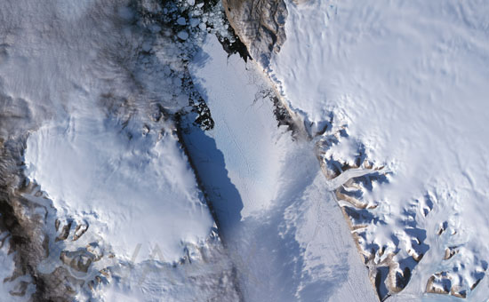
Crack in the Petermann Glacier, Greenland
author: Nasa/GSFC/Novapix
reference: t-eugro-00007
Image Size 300 DPI: 42 * 26 cm
Covering some 1,295 square kilometers (500 square miles) along the northwestern coast of Greenland, Petermann Glacier's floating ice tongue is the Northern Hemisphere's largest, and it has occasionally calved large icebergs. Between 2000 and 2001, the glacier lost nearly 87 square kilometers (34 square miles). Between July 10 and July 24, 2008, the glacier lost another 29 square kilometers (11 square miles). The Advanced Spaceborne Thermal Emission and Reflection Radiometer (ASTER) on NASA's Terra satellite captured this image of the rift on the Petermann Glacier on September 7, 2008. The rift, which appeared by 2001, is filled with thin ice and covered with snow. A thin fracture near the edge of the rift, however, indicates that it has continued to widen. After its initial formation, the rift on Petermann Glacier advanced toward the glacier front, widening as it moved. Satellite images from the 1990s show that rifts have developed in this region on the Petermann more than once, but previous rifts evolved differently than this one, which grew wider and longer. Byrd Polar Research Center scientists stated that if this rift extended completely across the glacier, the glacier could lose another 160 square kilometers (60 square miles)one third of its current length. The view shows areas of open water along the glacier's margins, and a profusion of ice fragments beyond the tip of the glacier tongue. As a glacier squeezes past the fjord walls, the interaction of the ice and rock produces backstress that keeps the ice relatively compressed. But as pieces of ice break away from the glacier, the backstress is reduced, and the glacier begins to stretch. The rift on this glacier is evidence of the glacier's stretching and thinning over time.
Keywords for this photo:
2008 - ASTER - EARTH - EARTH FROM SPACE - GLACIER - GREENHOUSE EFFECT - GREENLAND - ICE - ICEBERG - PETERMANN - SATELLITE IMAGE - TERRA - WARMING - WATER -
Contact : Stéphane Aubin +33-(0)9-51-26-53-76
© Novapix - All rights reserved


