
Photo Agency - Astronomy - Space - Nature


> Phoenix landing site, vertical projection
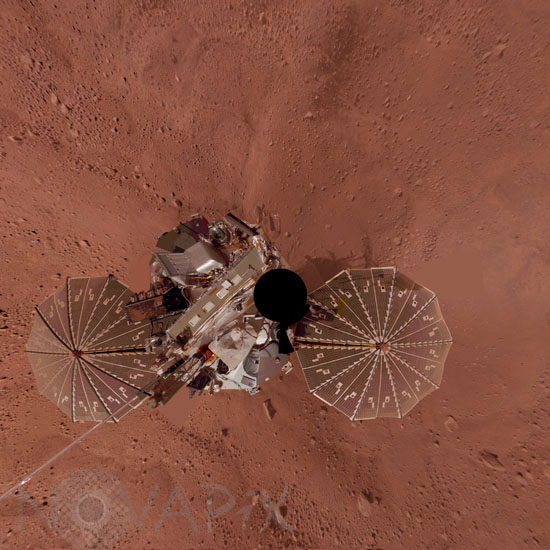
Phoenix landing site, vertical projection
author: NASA/JPL-Caltech/University of Arizona/Novapix
reference: a-mar12-00029
Image Size 300 DPI: 25 * 25 cm
This view is a vertical projection that combines hundreds exposures taken by the Surface Stereo Imager camera on NASA's Mars Phoenix Lander and projects them as if looking down from above. The black circle on the spacecraft is where the camera itself is mounted on the lander, out of view in images taken by the camera. North is toward the top of the image. The height of the lander's meteorology mast, extending toward the southwest, appears exaggerated because that mast is taller than the camera mast. This view is in approximately true color. The landing site is at 68.22 degrees north latitude, 234.25 degrees east longitude on Mars. The ground surface around the lander has polygonal patterning similar to patterns in permafrost areas on Earth. The images were taken throughout the period from the 13th Martian day, or sol, after landing to the 47th sol (June 5 through July 12, 2008).
Keywords for this photo:
2008 - ASTRONOMY - LANDSCAPE - MARS - MARTIAN SURFACE - PANORAMA - PHOENIX - PLANET - SAMPLE - SOIL - SOLAR PANEL - SPACECRAFT - SPACEPROBE - VASTITAS BOREALIS -
Contact : Stéphane Aubin +33-(0)9-51-26-53-76
© Novapix - All rights reserved