
Photo Agency - Astronomy - Space - Nature


> Lhasa in Tibet seen from space
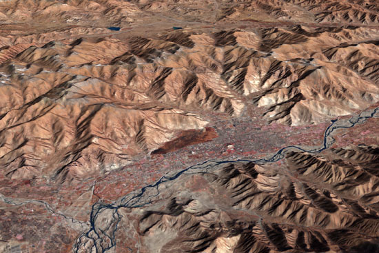
Lhasa in Tibet seen from space
author: Nasa/GSFC/Novapix
reference: t-astib-00004
Image Size 300 DPI: 20 * 13 cm
With an elevation of 3,650 meters (11,975 feet), Lhasa, the administrative capital of the Tibet Autonomous Region in China, is one of the highest elevation cities in the world. The city fills a flat river valley nestled in the ranges of the Himalaya Mountains in southern China. This image taken on November 24, 2005 from the Advanced Spaceborne Thermal Emission and Reflection Radiometer (ASTER) on NASAâs Terra satellite, provides a three-dimensional view of the landscape created from the instrumentâs stereo sensors. False color image in which plant-covered land is red, man-made surfaces tend to be silver or white, the high mountains are brown.
Keywords for this photo:
2005 - ASIA - ASTER - CAPITAL - CHINA - CITY - EARTH - EARTH FROM SPACE - FALSE COLOR - LHASA - MOUNTAIN - PLATEAU - SATELLITE IMAGE - TERRA - TIBET -
Contact : Stéphane Aubin +33-(0)9-51-26-53-76
© Novapix - All rights reserved