
Photo Agency - Astronomy - Space - Nature


> Satellite image of Paris
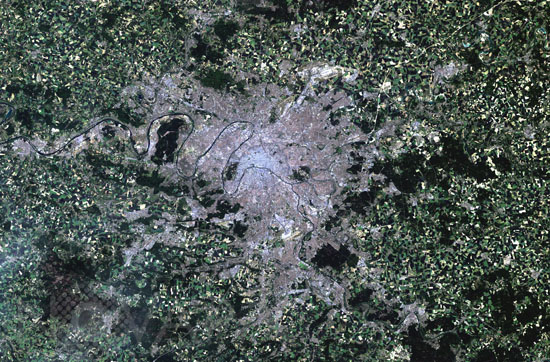
Satellite image of Paris
author: Nasa/Novapix
reference: t-eufra-00008
Image Size 300 DPI: 31 * 20 cm
This is a Landsat thematic mapper image of Paris, France, in 2004. Paris, known as the City of Light (la Ville Lumière), is built on an arc of the River Seine and is divided into two parts: the Right Bank to the north and the Left Bank to the south. Paris is divided into twenty numerically arranged districts called the arrondissements. These districts are numbered in a spiral pattern with the 1er arrondissement at the centre of the city. In the image, one can see the River Seine winding its way through the centre of the images. The grey and purple pixels denote the urban area. The heart of the city appears greyer than the suburbs. The patchwork of green, brown, tan and yellow surrounding the city is farmland. To the south of the city, the large bright area is Orly Airport and, at the top of the images, you can see a bright area which is the Charles de Gaulle International Airport in nearby Roissy-en-France.
Keywords for this photo:
2004 - CAPITAL - EARTH - EARTH FROM SPACE - EUROPE - FRANCE - ILE DE FRANCE - LANDSAT - LANDSAT-5 - MEANDER - PARIS - RIVER - SATELLITE IMAGE - SEINE -
Contact : Stéphane Aubin +33-(0)9-51-26-53-76
© Novapix - All rights reserved