
Photo Agency - Astronomy - Space - Nature


> Mt. Vesuvius, Italy, radar image. 04/1994
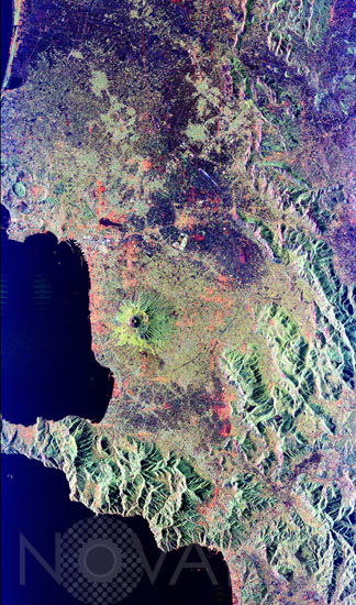
Mt. Vesuvius, Italy, radar image. 04/1994
author: Nasa/GSFC/Novapix
reference: t-euita-00003
Image Size 300 DPI: 15 * 26 cm
Mt. Vesuvius, one of the best known volcanoes in the world primarily for the eruption that buried the Roman city of Pompeii, is shown in the center of this radar image. The central cone of Vesuvius is the dark purple feature in the center of the volcano. This cone is surrounded on the northern and eastern sides by the old crater rim, called Mt. Somma. Recent lava flows are the pale yellow areas on the southern and western sides of the cone. The Bay of Naples, on the left side of the image, is separated from the Gulf of Salerno, in the lower left, by the Sorrento Peninsula. Dense urban settlement can be seen around the volcano. The city of Naples is above and to the left of Vesuvius; the seaport of the city can be seen in the top of the bay. Pompeii is located just below the volcano on this image.
Keywords for this photo:
1994 - EUROPE - ITALY - MOUNTAIN - RADAR - TYRRHENIAN SEA - VESUVIUS - VOLCANO -
Contact : Stéphane Aubin +33-(0)9-51-26-53-76
© Novapix - All rights reserved