
Photo Agency - Astronomy - Space - Nature


> Europe seen by the satellite Envisat
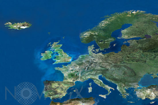
Europe seen by the satellite Envisat
author: Esa/Novapix
reference: t-europ-00001
Image Size 300 DPI: 67 * 45 cm
The crowning mosaic in the series represents approximately 1.6 million square kilometres of European territory at 300-metre resolution.
All the mosaics were produced using the Medium Resolution Imaging Spectrometer (MERIS) instrument on ESA's Envisat environmental satellite, working in full resolution mode. They are made up of around 160 separate MERIS images. Once the images are ordered they were georeferenced, then mosaicked together. A colour match is run and irregularities such as clouds had to be corrected for. Millions of clouds were masked and substituted with actual data. The mosaic scale is constant, so it needs more than six images to cover the whole of Germany while small countries like Luxembourg can be covered by only one image.
All the mosaics were produced using the Medium Resolution Imaging Spectrometer (MERIS) instrument on ESA's Envisat environmental satellite, working in full resolution mode. They are made up of around 160 separate MERIS images. Once the images are ordered they were georeferenced, then mosaicked together. A colour match is run and irregularities such as clouds had to be corrected for. Millions of clouds were masked and substituted with actual data. The mosaic scale is constant, so it needs more than six images to cover the whole of Germany while small countries like Luxembourg can be covered by only one image.
Keywords for this photo:
2003 - ATLANTIC OCEAN - BALTIC SEA - EARTH - EARTH FROM SPACE - ENVISAT - EUROPE - MEDITERRANEAN SEA - MERIS - NORTH SEA - POSTER - SATELLITE IMAGE -
Contact : Stéphane Aubin +33-(0)9-51-26-53-76
© Novapix - All rights reserved