
Photo Agency - Astronomy - Space - Nature


> Scandinavian Peninsula seen from satellite Sentinel-3
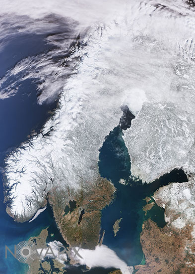
Scandinavian Peninsula seen from satellite Sentinel-3
author: Esa/Novapix
reference: t-eusue-00002
Image Size 300 DPI: 38 * 53 cm
The Copernicus Sentinel-3 mission captured this impressive shot of the almost cloud-free Scandinavian Peninsula on 20 March 2022.
The Scandinavian Peninsula, which comprises Sweden and Norway, is approximately 1850 km long. It extends southward from the Barents Sea in the north, the Norwegian sea to the west and the Gulf of Bothnia and the Baltic Sea to the east. Denmark, Finland, Latvia and Lithuania are also visible in this image.
Keywords for this photo:
2022 - DENMARK - EARTH - EARTH FROM SPACE - EUROPE - FINLAND - LATVIA - LITHUANIA - POSTER - SATELLITE IMAGE - SENTINEL - SENTINEL-3 - SNOW - SWEDEN -
Contact : Stéphane Aubin +33-(0)9-51-26-53-76
© Novapix - All rights reserved