
Photo Agency - Astronomy - Space - Nature


> Venus by Magellan spacecraft: Sapas Mons volcano
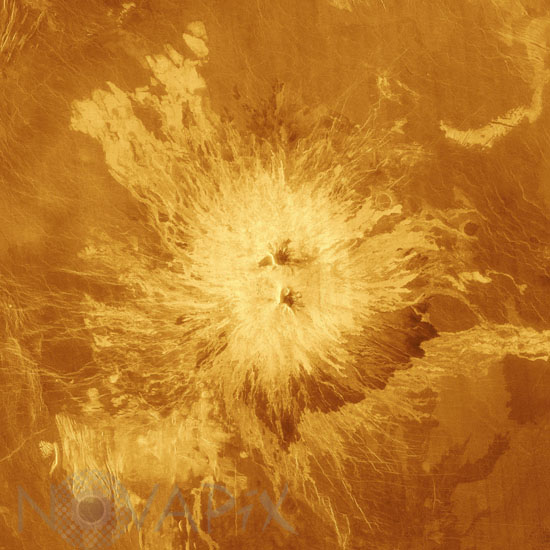
Venus by Magellan spacecraft: Sapas Mons volcano
author: Nasa/JPL/Novapix
reference: a-ven06-00024
Image Size 300 DPI: 26 * 26 cm
This false-color image shows the volcano Sapas Mons, which is located in the broad equatorial rise called Atla Regio (8 degrees north latitude and 188 degrees east longitude). The area shown is approximately 650 kilometers (404 miles) on a side. Sapas Mons measures about 400 kilometers (248 miles) across and 1.5 kilometers (0.9 mile) high. Its flanks show numerous overlapping lava flows. The dark flows on the lower right are thought to be smoother than the brighter ones near the central part of the volcano. Many of the flows appear to have been erupted along the flanks of the volcano rather than from the summit. This type of flank eruption is common on large volcanoes on Earth, such as the Hawaiian volcanoes. The summit area has two flat-topped mesas, whose smooth tops give a relatively dark appearance in the radar image. Also seen near the summit are groups of pits, some as large as one kilometer (0.6 mile) across. These are thought to have formed when underground chambers of magma were drained through other subsurface tubes and lead to a collapse at the surface. A 20 kilometer-diameter (12-mile diameter) impact crater northeast of the volcano is partially buried by the lava flows. Little was known about Atla Regio prior to Magellan. The new data, acquired in February 1991, show the region to be composed of at least five large volcanoes such as Sapas Mons, which are commonly linked by complex systems of fractures or rift zones. If comparable to similar features on Earth, Atla Regio probably formed when large volumes of molten rock upwelled from areas within the interior of Venus known as 'hot spots.'
Keywords for this photo:
1991 - ASTRONOMY - FALSE COLOR - LAVA - MAGELLAN - PLANET - RADAR - SAPAS MONS - VENUS - VOLCANO -
Contact : Stéphane Aubin +33-(0)9-51-26-53-76
© Novapix - All rights reserved