
Photo Agency - Astronomy - Space - Nature


> Altimetric map of earth.
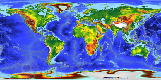
Altimetric map of earth.
author: ESA/Novapix
reference: t-glb50-00100
Image Size 300 DPI: 67 * 33 cm
This global map was realized by merging a bathymetry model and the Altimetry Corrected Elevations (ACE). For the ocean, the global bathymetry was constructed by blending depth soundings collected from ships with detailed gravity anomaly information obtained from the Geosat (US Navy) and ERS-1/2 (ESA) satellite altimetry missions. For the land elevation, database of ERS-1 satellite altimeter were reprocessed.
Keywords for this photo:
ALTIMETRY - CONTINENT - EARTH - EARTH FROM SPACE - ERS-1 - ERS-2 - GLOBAL VIEW - OCEAN - PLANET - PLANISPHERE - POSTER - RADAR - SATELLITE IMAGE - TOPOGRAPHY -
Contact : Stéphane Aubin +33-(0)9-51-26-53-76
© Novapix - All rights reserved