
Photo Agency - Astronomy - Space - Nature


> Mars: Phoenix landing site
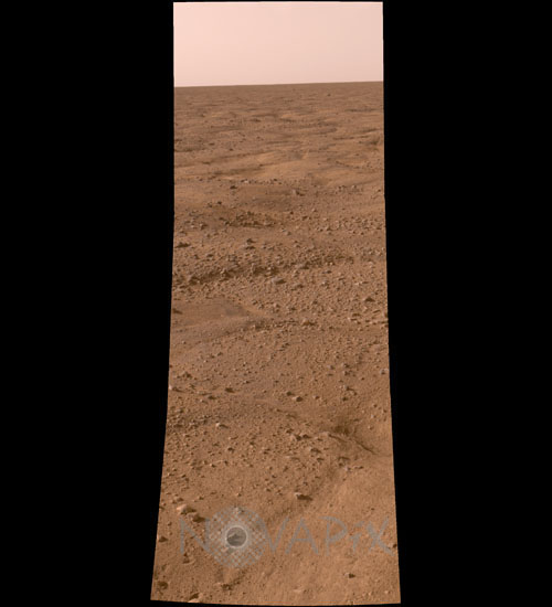
Mars: Phoenix landing site
author: NASA/JPL-Caltech/University of Arizona/Novapix
reference: a-mar12-00003
Image Size 300 DPI: 10 * 24 cm
This image, one of the first captured by NASA's Phoenix Mars Lander, shows the vast plains of the northern polar region of Mars. The flat landscape is strewn with tiny pebbles and shows polygonal cracking, a pattern seen widely in Martian high latitudes and also observed in permafrost terrains on Earth. The polygonal cracking is believed to have resulted from seasonal freezing and thawing of surface ice. Phoenix touched down on the Red Planet at 4:53 p.m. Pacific Time (7:53 p.m. Eastern Time), May 25, 2008, in an arctic region called Vastitas Borealis, at 68 degrees north latitude, 234 degrees east longitude. This is an approximate-color image taken shortly after landing by the spacecraft's Surface Stereo Imager, inferred from two color filters, a violet, 450-nanometer filter and an infrared, 750-nanometer filter.
Keywords for this photo:
2008 - ASTRONOMY - LANDSCAPE - MARS - MARTIAN SURFACE - PANORAMA - PHOENIX - PLANET - SOIL - VASTITAS BOREALIS -
Contact : Stéphane Aubin +33-(0)9-51-26-53-76
© Novapix - All rights reserved