
Photo Agency - Astronomy - Space - Nature


> Phoenix landing site, polar projection
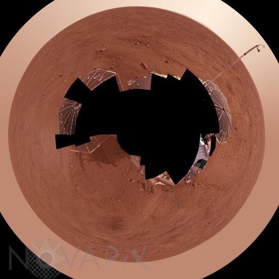
Phoenix landing site, polar projection
author: NASA/JPL-Caltech/University of Arizona/Novapix
reference: a-mar12-00026
Image Size 300 DPI: 50 * 50 cm
This view combines more than 400 images taken during the first several weeks after NASA's Phoenix Mars Lander arrived on an arctic plain at 62.22 degrees north latitude, 234.25 degrees east longitude on Mars. The full-circle panorama in approximately true color shows the polygonal patterning of ground at the landing area, similar to patterns in permafrost areas on Earth. South is toward the top. Trenches where Phoenix's robotic arm has been exposing subsurface material are visible in the lower half of the image. The spacecraft's meteorology mast, topped by the telltale wind gauge, extends into the sky portion of the panorama. This view comprises more than 100 different camera pointings, with images taken through three different filters at each pointing. It is presented here as a polar projection.
Keywords for this photo:
2008 - ASTRONOMY - LANDSCAPE - MARS - MARTIAN SURFACE - PANORAMA - PHOENIX - PLANET - POSTER - SAMPLE - SOIL - SOLAR PANEL - SPACECRAFT - SPACEPROBE - VASTITAS BOREALIS -
Contact : Stéphane Aubin +33-(0)9-51-26-53-76
© Novapix - All rights reserved