
Photo Agency - Astronomy - Space - Nature


> Bering Glacier in Alaska
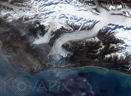
Bering Glacier in Alaska
author: Nasa/GSFC/USGS/Novapix
reference: t-naalk-00007
Image Size 300 DPI: 39 * 29 cm
Bering Glacier currently terminates in Vitus Lake south of Alaska's Wrangell-St. Elias National Park, about 10 km from the Gulf of Alaska. Combined with the Bagley Icefield, where the snow that feeds the glacier accumulates, the Bering is the largest glacier in North America. Warmer temperatures and changes in precipitation over the past century have thinned the Bering Glacier by several hundred meters. Since 1900 the terminus has retreated as much as 12 km. Most of the glaciers along the Alaskan coast are retreating along with the Bering Glacier. This true-color image of the Bering Glacier terminus was acquired on September 29, 2002, by the Enhanced Thematic Mapper plus (ETM+) instrument aboard the USGS/NASA Landsat-7 satellite.
Keywords for this photo:
2002 - ALASKA - BERING - EARTH - EARTH FROM SPACE - GLACIER - GREENHOUSE EFFECT - ICE - LANDSAT - LANDSAT-7 - MOUNTAIN - SATELLITE IMAGE - USA - WARMING - WATER -
Contact : Stéphane Aubin +33-(0)9-51-26-53-76
© Novapix - All rights reserved