
Photo Agency - Astronomy - Space - Nature


> Retreat of the Helheim Glacier, Greenland
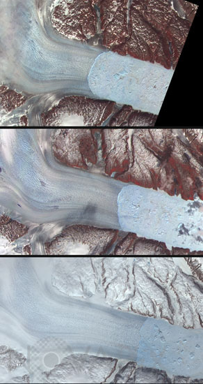
Retreat of the Helheim Glacier, Greenland
author: Nasa/GSFC/Novapix
reference: t-eugro-00006
Image Size 300 DPI: 14 * 25 cm
Along the margin of the Greenland Ice Sheet, outlet glaciers flow as icy rivers through narrow fjords and out to sea. As long as the thickness of the glacier and the depth of the water allow the ice to remain grounded, it stays intact. Where the ice becomes too thin or the water too deep, the edge floats and rapidly crumbles into icebergs. Satellite observations of eastern Greenland's Helheim Glacier show that the position of the iceberg's calving front, or margin, has undergone rapid and dramatic change since 2001, and the glacier's flow to the sea has sped up as well. These images from the Advanced Spaceborne Thermal Emission and Reflection Radiometer (ASTER) on NASA's Terra satellite show the Helheim glacier in June 2005 (top), July 2003 (middle), and May 2001 (bottom). The glacier occupies the left part of the images, while large and small icebergs pack the narrow fjord in the right part of the images. Bare ground appears brown or tan, while vegetation appears in shades of red. From the 1970s until about 2001, the position of the glacier's margin changed little. But between 2001 and 2005, the margin retreated landward about 7.5 kilometers (4.7 miles), and its speed increased from 8 to 11 kilometers per year. Between 2001 and 2003, the glacier also thinned by up to 40 meters (about 131 feet). Overall, the margins of the Greenland Ice Sheet have been thinning by tens of meters over the last decade.
Keywords for this photo:
2001 - 2003 - 2005 - ASTER - COMPARISON - EARTH - EARTH FROM SPACE - GLACIER - GREENHOUSE EFFECT - GREENLAND - HELHEIM - ICE - SATELLITE IMAGE - TERRA - WARMING - WATER -
Contact : Stéphane Aubin +33-(0)9-51-26-53-76
© Novapix - All rights reserved