Photo Agency - Astronomy - Space - Nature

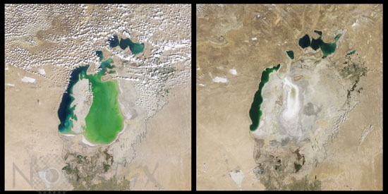
Evaporation of the Aral Sea
auteur: Nasa/Novapix
référence: t-askaz-00010
Image Size 300 DPI: 35 * 17 cm
Comparison of satellite images taken on august 19 2000 (left) and august 16 2009 (right) by satellite Terra. Approximate shoreline in 1960 has been added. The Aral Sea, is actually a lake rather than a sea. In the 1960s, the Soviet Union began a massive irrigation project in what are now Kazakhstan, Uzbekistan, and Turkmenistan, diverting water from the rivers that feed the Aral Sea to irrigate farmland. Although the Northern Aral Sea (upper right) still appears healthy, the Southern Aral Sea consists of two isolated water bodies: an irregular oval shape directly southwest of the Northern Aral Sea, and the long, thin remainder of the Southern Aral Sea’s far western lobe. Although the faintest glimmers of blue-green appear in the eastern lobe, earth tones predominate, surrounded by a ghostly film of pale beige. Lake sediments from this depleted water body have provided ample material for frequent dust storms. Much of what finally doomed the Southern Aral Sea was an attempt to save its neighbor to the north. In 2005, Kazakhstan built the Kok-Aral Dam between the lake’s northern and southern portions to preserve water levels in the north. The Northern Aral Sea actually exceeded expectations with the speed of its recovery, but the dam ended prospects for a recovery of the Southern Aral Sea, which some authorities already regarded as beyond help.
Keywords for this photo:
1960 - 2000 - 2009 - ARAL SEA - ASIA - COMPARISON - DESERTIFICATION - EARTH - EARTH FROM SPACE - KAZAKHSTAN - SATELLITE IMAGE - SEA - TERRA - UZBEKISTAN - WATER -
Contact : Stéphane Aubin +33-(0)9-51-26-53-76
© Novapix - All rights reserved


