Photo Agency - Astronomy - Space - Nature

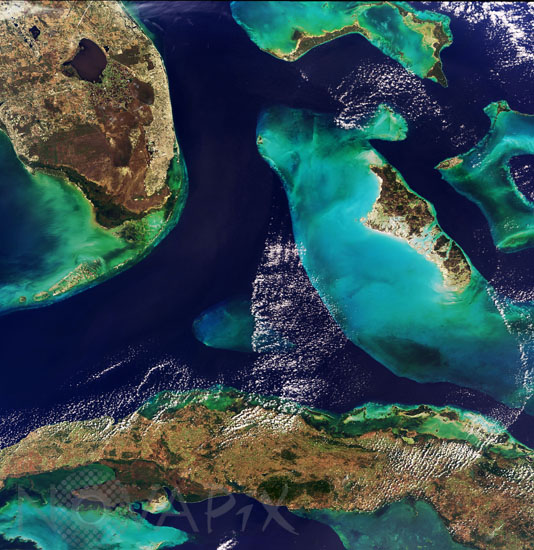
Cuba, Florida and Bahamas from satellite Envisat
auteur: ESA/Novapix
référence: t-nacub-00003
Image Size 300 DPI: 28 * 29 cm
The shallow blue waters of the Bahamas as seen from Envisat 800km away in space, acquired by the Medium Resolution Imaging Spectrometer (MERIS) on 24 January 2004. The Bahamas consist of a chain of islands and shallow water banks extending 1400 km from Florida to the island of Hispaniola. All the islands are surrounded by coral reefs - 5% of all the world's coral reefs are concentrated here. At the top left of the image is the southern tip of Florida, reaching from the circular Lake Okeechobee down through the Everglades all the way to Key West. The top of the curved archipelago of islands and associated coral reefs known as the Florida Keys is also visible. At the image base is the island of Cuba, 145 km south of Florida: the shaded area on the south face of the island is the swampy Zapata Peninsula National Park, while the rounded dark zone east of it corresponds to the verdant Sierra Del Escambray mountain range, including the 1160-metre-high Pico San Juan, Cuba's second highest peak. Between Florida and Cuba is the Cay Sal bank, appearing as a small area of light blue water. To the east is Andros Island, which can be seen, like most Bahaman islands, to be located on the east side of a shallowly-submerged water platform. The Biminis are formed from the top left of this same platform. Above Andros Island is Grand Bahama, with Nassau on its east side.
Keywords for this photo:
2004 - ATLANTIC OCEAN - BAHAMAS - CORAL - CUBA - EARTH - EARTH FROM SPACE - ENVISAT - FLORIDA - ISLAND - MERIS - OCEAN - SATELLITE IMAGE - WATER -
Contact : Stéphane Aubin +33-(0)9-51-26-53-76
© Novapix - All rights reserved


