Photo Agency - Astronomy - Space - Nature

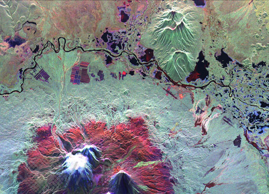
Radar image of Kliuchevskoi volcano
auteur: Nasa/Novapix
référence: t-asrus-00005
Image Size 300 DPI: 10 * 7 cm
This is an image of the Kliuchevskoi volcano, Kamchatka, Russia, which began to erupt on September 30, 1994. Kliuchevskoi is the bright white peak surrounded by red slopes in the lower left portion of the image. The image was acquired by the Spaceborne Imaging Radar-C and X-band Synthetic Aperture Radar aboard the space shuttle Endeavour on its 25th orbit on October 1, 1994. The image shows an area approximately 30 kilometers by 60 kilometers (18.5 miles by 37 miles) that is centered at 56.18 degrees north latitude and 160.78 degrees east longitude. North is toward the top of the image. The Kamchatka volcanoes are among the most active volcanoes in the world. .
Keywords for this photo:
1994 - ASIA - EARTH - EARTH FROM SPACE - FALSE COLOR - KAMCHATKA - KLIUCHEVSKOI - KLIUCHEVSKOI VOLCANO - RADAR - RUSSIA - SIBERIA - STS-68 - VOLCANO -
Contact : Stéphane Aubin +33-(0)9-51-26-53-76
© Novapix - All rights reserved


