Photo Agency - Astronomy - Space - Nature

Umnak Island - Aleutian Islands - Alaska
auteur: Nasa/USGS/Novapix
référence: t-naalk-00008
Image Size 300 DPI: 92 * 60 cm
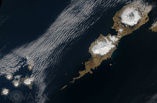
On May 3, 2014, the Landsat 8 satellite acquired this natural-color image of Umnak Island and its volcanic neighbors in the Aleutian Island chain. Part of the Fox Islands, Umnak is the third largest in the Aleutian chain and lies just southwest of Unalaska.
Umnak is mostly unpopulated, with roughly 40 people living in the village of Nikolski near the southwest tip of the island. Being a volcanic island, Umnak has numerous mud pots, hot springs, and the only geysers in Alaska.
The landscape is dominated by volcanoes. On the northern half of the island, Okmok—site of the 2008 eruption—rises 1073 meters (3,520 feet) above sea level as a broad shield volcano with a caldera nestled near the top. A crater lake sits amidst the volcanic ash and debris in the caldera. Mount Vsevidof, a symmetrical stratovolcano, rises 2149 meters (7,050 feet) and dominates the skyline of the southern portion of Umnak Island. The volcanic Islands of the Four Mountains are also visible in the lower left of the wide image.
Keywords for this photo:
2014 - ALASKA - ALEUTIAN ISLANDS - CALDERA - EARTH - EARTH FROM SPACE - ISLAND - LANDSAT - LANDSAT-8 - POSTER - SATELLITE IMAGE - USA - VOLCANO -
Contact : Stéphane Aubin +33-(0)9-51-26-53-76
© Novapix - All rights reserved


