Photo Agency - Astronomy - Space - Nature

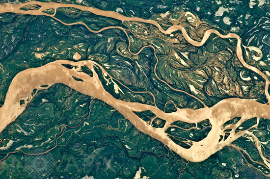
Parana River in Argentina
auteur: Nasa/Novapix
référence: t-saarg-00005
Image Size 300 DPI: 36 * 24 cm
The Paraná River is South America’s second largest, and the river and its tributaries are important transportation routes for landlocked cities in Argentina, Paraguay, Bolivia, and Brazil. This astronaut photograph shows a 29-kilometer (18 mile) stretch of the Paraná, downstream of the small city of Goya, Argentina (just off the top left of the image).
The Paraná River ranges up to 3 kilometers wide along the reach illustrated in this image. The Paraná floodplain occupies the entire image; it is so wide—18 kilometers (11 miles) in this view—that its banks are not visible. Numerous curved, meandering channels are the most prominent characteristic of the floodplain, indicating prior positions of the river and its channels. As riverbeds move laterally by natural processes, they leave remnants of their channels, which appear as lakes and finally fill with mud. This is an excellent image for illustrating these meander forms. Image taken from the International Space Station (ISS) on april 9 2011.
Keywords for this photo:
2011 - ARGENTINA - EARTH - EARTH FROM SPACE - EXPEDITION 27 - MEANDER - PARANA - RIVER - SOUTH AMERICA - WATER -
Contact : Stéphane Aubin +33-(0)9-51-26-53-76
© Novapix - All rights reserved


