Photo Agency - Astronomy - Space - Nature

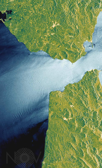
Strait of Gibraltar seen from space
auteur: ESA/Novapix
référence: t-eugib-00005
Image Size 300 DPI: 11 * 18 cm
A radar image of the Strait of Gibraltar acquired on May 20, 2002, by Envisat's Advanced Synthetic Aperture Radar (ASAR), a successor to the SAR flown on ESA's European Remote Sensing satellites (ERS) able to collect high-resolution imagery through multiple polarization geometries.
Seas exposed to strong easterly winds are shown in bright blue. Darker areas are sheltered by the mountain ranges in Spain and Morocco, and thus subjected to lighter winds. Large wave patterns between the two areas are associated with varying wind speeds at sea surface and are caused by atmospheric waves that have formed behind the mountain ranges of the Moroccan peninsula. Such information is useful to understand the climatology in this region where the Mediterranean Sea meets the Atlantic Ocean and strong currents and winds are common. On land, this high-resolution image shows a detailed topographic profile, provides information on vegetation, and shows the harbours of Cadiz and Gibraltar, and the runway of the airport of Gibraltar.
Contact : Stéphane Aubin +33-(0)9-51-26-53-76
© Novapix - All rights reserved


