Photo Agency - Astronomy - Space - Nature

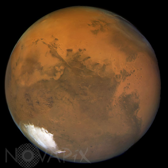
Mars seen by the Hubble space telescope in 2003
auteur: Nasa/Novapix
référence: a-mar02-00021
Image Size 300 DPI: 15 * 15 cm
This view of Mars reveals small craters and other surface markings only about a dozen miles (a few tens of kilometers) across. The Advanced Camera for Surveys (ACS) aboard NASA's Hubble Space Telescope snapped this image on Aug. 24 , 2003, just a few days before the red planet's historic "close encounter" with Earth. Among the Martian surface features are: numerous craters; several large volcanoes of the great Tharsis plateau along the upper left limb; and a large multi-ring impact basin, called Argyre, near image center. Subtle outliers of bright, whitish carbon dioxide ice (dry ice) can be seen in the neighborhood of the subliming white south polar cap at lower left, near the bottom of the image. The bright reddish meandering lines seen within the dark regions near the center of the image are caused by sunlight reflecting off the sloping walls of a giant canyon system called Valles Marineris, which cuts across more than 2,000 miles of the planet's surface. This color image also reveals interesting weather phenomena at the highest northern latitudes. Hubble resolves a variety of clouds over the dark region in the upper right. This region is called Acidalia Planitia, and it is known to be the location of frequent cloud activity. The color image shows that there are both dust clouds (reddish/yellow) and ice clouds (blueish/white) over Acidalia. There is even some evidence of wave structures or other large-scale organized meteorological activity. If these are storms or storm fronts, they may be associated with the large amount of carbon dioxide condensation that is happening in the northern winter polar regions, where the north polar cap has started forming during the long polar night. Missing data at about the eight o'clock position have been filled.
Keywords for this photo:
2003 - ACS - ASTRONOMY - GLOBAL VIEW - HST - HUBBLE SPACE TELESCOPE - MARS - OPPOSITION - PLANET - POLE - SOUTH POLE -
Contact : Stéphane Aubin +33-(0)9-51-26-53-76
© Novapix - All rights reserved


