
Photo Agency - Astronomy - Space - Nature


> Earth from space gallerie
 |
 |
SlideShow Image 1038 / 2740 |  |
 |
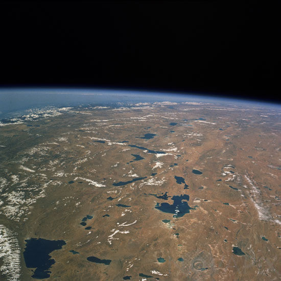
The Tibetan plateau from space
auteur: Nasa/Novapix
référence: t-astib-00003
Image Size 300 DPI: 44 * 44 cm
The southeast portion of the high Tibetan Plateau, called the Northern Plain by the Chinese, is seen in this southwest-looking, high-oblique photograph taken by astronauts in the space shuttle Columbia in october 1993 . Many great rivers originate in the Tibetan PlateauâIndus, Brahmaputra, Sutlej, Salween, Mekong, Yangtze, and Yellow. The plateau has no river system; however, it has numerous brackish lakes, some of which are visible in this photograph. Saline Namco Lake (southeast corner of photograph), the largest lake in Tibet, covers 950 square miles (2461 square kilometers) and sits at an altitude of 15 180 feet (4630 meters).
Keywords for this photo:
1993 - ASIA - ATMOSPHERE - CHINA - EARTH - EARTH FROM SPACE - HIMALAYAS - LAKE - LIMB - MOUNTAIN - PLATEAU - STS-58 - TIBET -
Contact : Stéphane Aubin +33-(0)9-51-26-53-76
© Novapix - All rights reserved