
Photo Agency - Astronomy - Space - Nature


> Earth from space gallerie
 |
 |
SlideShow Image 422 / 2740 |  |
 |
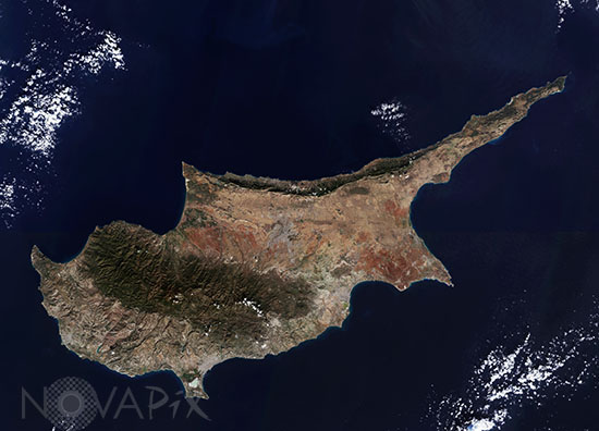
Cyprus seen from satellite
auteur: Esa/Novapix
référence: t-euchy-00002
Image Size 300 DPI: 84 * 60 cm
The third largest island in the Mediterranean, Cyprus is about 240 km long and 100 km wide. It is located on the Anatolian plate and therefore belongs geologically to Asia, but politically it is a member of the EU.
The Troodos mountains dominate the centre of the island and include Mount Olympus, the countryâs highest mountain at 1952 m.
The capital and largest city, Nicosia, sits between the two mountain ranges. Since 1974 the island has been split between the Greek Cypriot and Turkish Cypriot populations, with the line of separation running through the city.
Image taken on december 22nd 2015 by Sentinel-2A satellite.
Keywords for this photo:
2015 - CYPRUS - EARTH - EARTH FROM SPACE - EUROPE - ISLAND - MEDITERRANEAN SEA - POSTER - SATELLITE IMAGE - SENTINEL - SENTINEL-2 -
Contact : Stéphane Aubin +33-(0)9-51-26-53-76
© Novapix - All rights reserved