
Photo Agency - Astronomy - Space - Nature


> Earth from space gallerie
 |
 |
SlideShow Image 359 / 2740 |  |
 |
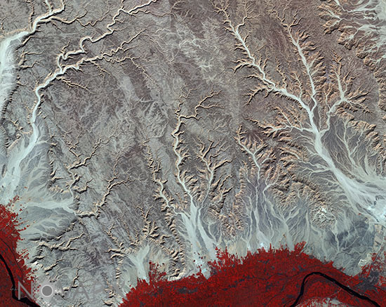
Eastern Desert - Egypt
auteur: ESA/Novapix
référence: t-afegy-00037
Image Size 300 DPI: 53 * 42 cm
The Sentinel-2A satellite takes us over central-eastern Egypt with this image from 17 January. The image is dominated by arid desert â namely the Eastern Desert between the Nile River the Red Sea. The distinctive pattern of water erosion from rivers and streams is clearly visible as they make their way towards the Nile, at which point the rolling sandy highlands drop abruptly at the Nile valley, visible along the bottom of the image. Fields of intensive farming along the Nile appear red owing to this false-colour image being processed to include the near-infrared. The varying shades of red indicate how sensitive the multispectral instrument on Sentinel-2 is to differences in chlorophyll content, providing key information on plant health. Zooming in along the bottom we can see clusters of black dots where cities and towns are located, in addition to the fields. In the lower right, just above the red area, there is an interesting pattern of roads from our birdâs-eye view â possibly a developing residential area.
Keywords for this photo:
2016 - AFRICA - DESERT - EARTH - EARTH FROM SPACE - EGYPT - INFRARED - NILE - POSTER - RIVER - SATELLITE IMAGE - SENTINEL - SENTINEL-2 - WATER -
Contact : Stéphane Aubin +33-(0)9-51-26-53-76
© Novapix - All rights reserved