
Photo Agency - Astronomy - Space - Nature


> Earth from space gallerie
 |
 |
SlideShow Image 360 / 2740 |  |
 |
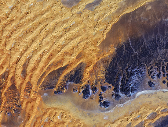
Algerian Sahara seen from space
auteur: ESA/JAXA/Novapix
référence: t-afalg-00009
Image Size 300 DPI: 42 * 32 cm
This satellite image was captured over southeastern Algeria in the heart of the Sahara desert. In this image, a large area of rock appearing purple stretches across the right side of the image, with fluvial erosion patterns testament to an earlier time when the area received more rainfall. Today, this area sees an average of about 10 mm of rainfall per year. Wind-shaped sand dunes are visible on the left. The area at the bottom appears to be flat, with tiny specks of vegetation.
Just south of this image lies the Tassili nâAjjer National Park and UNESCO World Heritage Site, renowned for its 10 000 year-old cave art. The drawings and engravings depict culture and the environment from a time when climatic conditions were more favourable to human occupation.
Japanâs ALOS satellite recorded this image on 28 January 2011.
Contact : Stéphane Aubin +33-(0)9-51-26-53-76
© Novapix - All rights reserved