
Photo Agency - Astronomy - Space - Nature


> Earth from space gallerie
 |
 |
SlideShow Image 2520 / 2740 |  |
 |
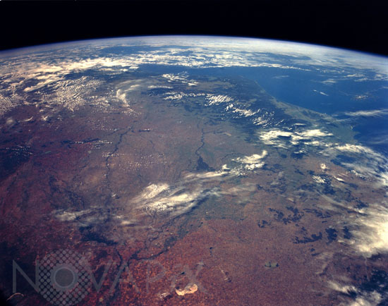
Murray River Basin, New South Wales and Victoria, Australia
auteur: Nasa/Novapix
référence: t-ocaus-00004
Image Size 300 DPI: 43 * 34 cm
In this high-oblique, south-southeast-looking photograph, the Murray River Basin and the southeast coastline of Australia are apparent. The dark green forested areas, inland from the coast and partially obscured by clouds, are the Australian Alps. The principal river of Australia, the Murray, is 1609 miles (2589 kilometers) long. Near the Murray's source in the Australian Alps is the Hume Reservoir (barely visible in the photograph), which helps regulate the river's flow and provides water for extensive pasturelands and areas where citrus fruits, vegetables, and vine products are grown. Extensive agricultural field patterns are scattered throughout the region. Near the center of the photograph is a large, green, delta-shaped region, which is the remnants of an old Murray River delta formed millions of years ago when the climate was much wetter. Northwest of the delta lies Lake Tyrrel, an almost dry lakebed. Northeast of Lake Tyrrel the waters of the Murrumbidgee River enter the Murray River.
Keywords for this photo:
1993 - ATMOSPHERE - AUSTRALIA - BASSIN - EARTH - EARTH FROM SPACE - HORIZON - LIMB - MURRAY - RIVER - STS-56 - WATER -
Contact : Stéphane Aubin +33-(0)9-51-26-53-76
© Novapix - All rights reserved