
Photo Agency - Astronomy - Space - Nature


> Earth from space gallerie
 |
 |
SlideShow Image 2518 / 2740 |  |
 |
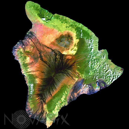
The Big Island of Hawaii
auteur: Nasa/Noaa/Novapix
référence: t-ochaw-00002
Image Size 300 DPI: 42 * 42 cm
This false-color composite (processed to simulate true color) image of Hawaii, the largest of the Hawaiian Islands, was constructed from data gathered between 1999 and 2001 by the Landsat 7 satellite. Hawaii was created by a hotspot beneath the ocean floor. Hotspots form in areas where superheated magma in the Earth's mantle breaks through the Earth's crust. Over the course of millions of years, the Pacific Tectonic Plate has slowly moved over this hotspot to form the entire Hawaiian Island archipelago. The black areas on the island (in this scene) that resemble a pair of sun-baked palm fronds are hardened lava flows formed by the active Mauna Loa Volcano. Just to the north of Mauna Loa is the dormant grayish Mauna Kea Volcano, which hasn't erupted in an estimated 3,500 years. A thin greyish plume of smoke is visible near the island's southeastern shore, rising from Kilauea-the most active volcano on Earth. Heavy rainfall and fertile volcanic soil have given rise to Hawaii's lush tropical forests, which appear as solid dark green areas in the image. The light green, patchy areas near the coasts are likely sugar cane plantations, pineapple farms, and human settlements.
Contact : Stéphane Aubin +33-(0)9-51-26-53-76
© Novapix - All rights reserved