
Photo Agency - Astronomy - Space - Nature


> Earth from space gallerie
 |
 |
SlideShow Image 2451 / 2740 |  |
 |
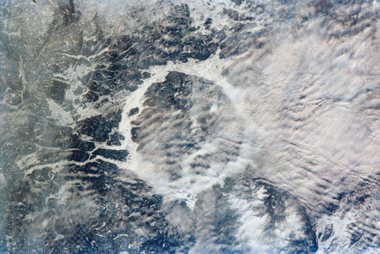
Manicouagan impact crater
auteur: Nasa/Novapix
référence: t-cra06-00001
Image Size 300 DPI: 25 * 16 cm
Low clouds (center right) partially obscure a portion of the ice-covered Manicouagan Reservoir located in the Canadian Shield of Quebec Province in eastern Canada, in this 70mm photograph recorded aboard the Space Shuttle Atlantis. This reservoir marks the site of an impact crater, 60 miles (100 kilometers) wide, which, according to geologists, was formed 212 million years ago when a meteorite crashed into this area. Over millions of years, the many advancing and retreating glaciers and other erosional processes have worn down the crater, the geologists say. Manicouagan Reservoir connects to the Manicouagan River on the south (left center). 04/2002.
Keywords for this photo:
2002 - CANADA - CLOUD - EARTH - EARTH FROM SPACE - IMPACT - IMPACT CRATER - MANICOUAGAN - QUEBEC - STS-110 - TRIASSIC -
Contact : Stéphane Aubin +33-(0)9-51-26-53-76
© Novapix - All rights reserved