
Photo Agency - Astronomy - Space - Nature


> Earth from space gallerie
 |
 |
SlideShow Image 2382 / 2740 |  |
 |
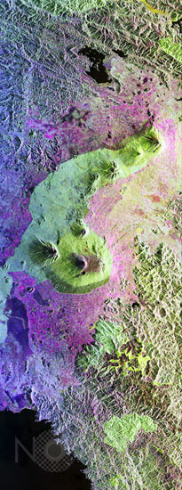
The Virunga Volcano chain
auteur: Nasa/Novapix
référence: t-afrca-00001
Image Size 300 DPI: 8 * 22 cm
This is a false-color radar image of Central Africa, showing the Virunga Volcano chain along the borders of Rwanda, Zaire (Democratic republic of the Congo) and Uganda. This area is home to the endangered mountain gorillas. This C- and L-band image was acquired on April 12, 1994, from space shuttle Endeavour by the Spaceborne Imaging Radar-C/X-band Synthetic Aperture Radar (SIR-C/X-SAR). The image covers an area 58 kilometers by 178 kilometers (48 miles by 178 miles). The dark area in the bottom of the image is Lake Kivu, which forms the border between Zaire (to the left) and Rwanda (to the right). The airport at Goma, Zaire is shown as a dark line just above the lake in the bottom left corner of the image. Volcanic flows from the 1977 eruption of Mt. Nyiragongo are shown just north of the airport. Mt. Nyiragongo is not visible in this image because it is located just to the left of the image swath. The large volcano in the center of the image is Mt. Karisimbi (4,500 meters or 14,800 feet). This radar image highlights subtle differences in the vegetation and volcanic flows of the region. The faint lines shown in the purple regions are believed to be the result of agriculture terracing by the people who live in the region.
Keywords for this photo:
1994 - AFRICA - DEMOCRATIC REPUBLIC OF CONGO - EARTH - EARTH FROM SPACE - FALSE COLOR - RADAR - RWANDA - VIRUNGA - VOLCANO - ZAIRE -
Contact : Stéphane Aubin +33-(0)9-51-26-53-76
© Novapix - All rights reserved