
Photo Agency - Astronomy - Space - Nature


> Earth from space gallerie
 |
 |
SlideShow Image 2344 / 2740 |  |
 |
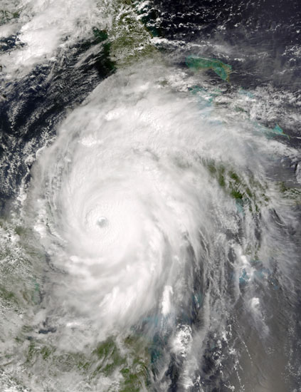
Hurricane Ivan seen by satellite Terra. 09/2004
auteur: Nasa/GSFC/Novapix
référence: t-nua01-00325
Image Size 300 DPI: 50 * 66 cm
Category 5 storm, Hurricane Ivan is moving between Cuba, right, and the Yucatan Peninsula, left into the Gulf of Mexico. When the NASA's Terra satellite acquired this image at 15:55 UTC (10:55 a.m. EDT) on September 13, 2004, the storm boasted winds of 260 kilometers per hour (160 mph). The storm was located about 110 kilometers southeast of Cuba, and was moving northwest at 13 kilometers per hour (8 mph).
Ivan appears to have grown in size over the last 24 hours. Hurricane force winds extend outward up to 185 km (115 miles) from the storm's center, with tropical storm force winds extend outward up to 354 km (220 miles).
Ivan appears to have grown in size over the last 24 hours. Hurricane force winds extend outward up to 185 km (115 miles) from the storm's center, with tropical storm force winds extend outward up to 354 km (220 miles).
Keywords for this photo:
2004 - CLOUD - CYCLONE - DEPRESSION - EARTH - EARTH FROM SPACE - HURRICANE - IVAN - METEOROLOGY - MODIS - OCEAN - POSTER - SATELLITE IMAGE - STORM - TERRA - TROPICAL STORM -
Contact : Stéphane Aubin +33-(0)9-51-26-53-76
© Novapix - All rights reserved