
Photo Agency - Astronomy - Space - Nature


> Earth from space gallerie
 |
 |
SlideShow Image 2257 / 2740 |  |
 |
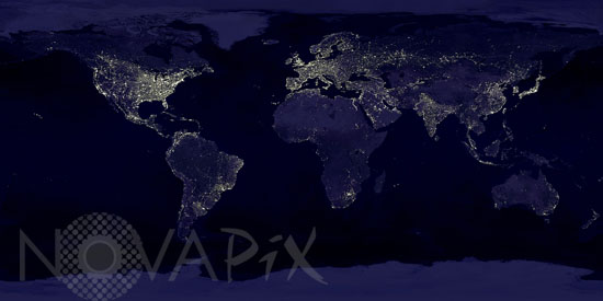
Earth by night
auteur: NASA/GSFC/DMSP/Novapix
référence: t-glb54-00001
Image Size 300 DPI: 20 * 10 cm
The image is a composite of hundreds of pictures made by the Defense Meteorological Satellite Program (DMSP) currently operates four satellites carrying the Operational Linescan System (OLS) in low-altitude polar orbits. Three of these satellites record nighttime data. The DMSP-OLS has a unique capability to detect low levels of visible-near infrared (VNIR) radiance at night. With the OLS 'VIS' band data it is possible to detect clouds illuminated by moonlight, plus lights from cities, towns, industrial sites, gas flares, and ephemeral events such as fires and lightning-illuminated clouds. October 1994 - March 1995 DMSP nighttime data collected when moonlight was low. Using the OLS thermal infrared band, areas containing clouds were removed and the remaining area used in the time series.
Keywords for this photo:
1995 - EARTH - EARTH FROM SPACE - GLOBAL VIEW - LIGHT - LIGHT POLLUTION - NIGHT - PLANET - PLANISPHERE - SATELLITE IMAGE -
Contact : Stéphane Aubin +33-(0)9-51-26-53-76
© Novapix - All rights reserved