
Photo Agency - Astronomy - Space - Nature


> Earth from space gallerie
 |
 |
SlideShow Image 1932 / 2740 |  |
 |
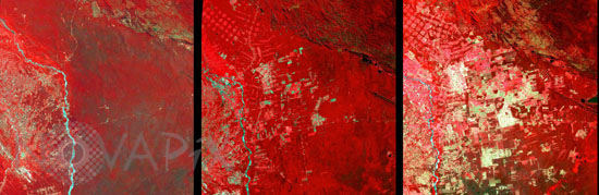
Deforestation in Bolivia
auteur: Nasa/USGS/Novapix
référence: t-sabol-00001
Image Size 300 DPI: 26 * 8 cm
Iimages, from Landsat 2, 4, and 7, showing the progression of deforestation in Bolivia from 1975 to 2000.
This area, in east of Santa Cruz de la Sierra, Bolivia, was a tropical forest. A large agricultural development, particularly soybean production began in earnest in the early 1970s, has lead to this area's deforestation.
Vegetation appears in red colored areas in these three images obtained by the Landsat satellite, from left to right : Landsat-2 on June 17 1975, Landsat-4 on July 10 1992 and Landsat-7 on August 01 2000.
Contact : Stéphane Aubin +33-(0)9-51-26-53-76
© Novapix - All rights reserved