
Photo Agency - Astronomy - Space - Nature


> Earth from space gallerie
 |
 |
SlideShow Image 1929 / 2740 |  |
 |
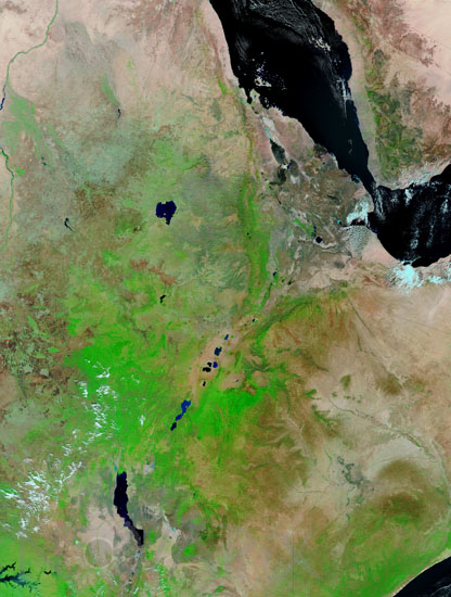
Eastern Africa by Terra satellite
auteur: Nasa/GSFC/Novapix
référence: t-afeth-00002
Image Size 300 DPI: 48 * 64 cm
False-color image taken by the satellite Terra in january 2003. Here is the eastern area of Africa showing the Afar depression, the junction of three tectonic plates.
Most of the image shows Ethiopia crossed by the Rift.
The vegetation is bright green, naturally bare soil is pinkish tan, burn scars are reddish brown, water is dark blue or black, and clouds are light blue or white.
NB : border lines are marked
Most of the image shows Ethiopia crossed by the Rift.
The vegetation is bright green, naturally bare soil is pinkish tan, burn scars are reddish brown, water is dark blue or black, and clouds are light blue or white.
NB : border lines are marked
Keywords for this photo:
2003 - AFAR - AFAR DEPRESSION - AFRICA - ASIA - BORDER - CONTINENTAL DRIFT - DESERT - DJIBOUTI - EARTH - EARTH FROM SPACE - ERITREA - ETHIOPIA - FALSE COLOR - GULF OF ADEN - KENYA - LAKE - LAKE TURKANA - RED SEA - RIFT - SATELLITE IMAGE - SOMALIA - TECTONIC - TERRA - TURKANA - YEMEN -
Contact : Stéphane Aubin +33-(0)9-51-26-53-76
© Novapix - All rights reserved