
Photo Agency - Astronomy - Space - Nature


> Earth from space gallerie
 |
 |
SlideShow Image 1885 / 2740 |  |
 |
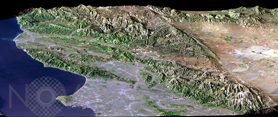
Los Angeles and the San Andreas fault
auteur: Nasa/USGS/Novapix
référence: t-nacal-00003
Image Size 300 DPI: 37 * 16 cm
Perspective view of Los Angeles, San Gabriel Mountains and Mojave Desert. The San Andreas fault divides the region in forming a straight topographical boundary between the top center and lower right corner of the image.
Landsat-7 picture acquired on May 4 2001 combined
with a radar image from SRTM, on board the space shuttle Endeavour on February 11 2000.
Landsat-7 picture acquired on May 4 2001 combined
with a radar image from SRTM, on board the space shuttle Endeavour on February 11 2000.
Keywords for this photo:
2001 - CITY - EARTH - EARTH FROM SPACE - FAULT - GEOLOGY - LANDSAT - LANDSAT-7 - LOS ANGELES - MOUNTAIN - RADAR - SAN ANDREAS - SRTM - TECTONIC - USA - VALLEY -
Contact : Stéphane Aubin +33-(0)9-51-26-53-76
© Novapix - All rights reserved