
Photo Agency - Astronomy - Space - Nature


> Earth from space gallerie
 |
 |
SlideShow Image 1687 / 2740 |  |
 |
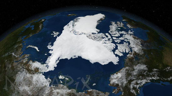
Arctic minimum sea ice extent- September 14, 2007.
auteur: Nasa/GSFC/Novapix
référence: t-arc01-00008
Image Size 300 DPI: 32 * 18 cm
This image shows the minimum sea ice extent that occurred on September 14, 2007.
Sea ice is frozen seawater floating on the surface of the ocean. Some sea ice is semi-permanent, persisting from year to year, and some is seasonal, melting and refreezing from season to season. The sea ice cover reaches its minimum extent at the end of each summer and the remaining ice is called the perennial ice cover. The 2007 Arctic summer sea ice has reached the lowest extent of perennial ice cover on record - nearly 25% less than the previous low set in 2005. The area of the perennial ice has been steadily decreasing since the satellite record began in 1979, at a rate of about 10% per decade. But the 2007 minimum, reached on September 14, is far below the previous record made in 2005 and is about 38% lower than the climatological average. Such a dramatic loss has implications for ecology, climate and industry.
Image made from Aqua satellite instrument.
Contact : Stéphane Aubin +33-(0)9-51-26-53-76
© Novapix - All rights reserved