
Photo Agency - Astronomy - Space - Nature


> Earth from space gallerie
 |
 |
SlideShow Image 1651 / 2740 |  |
 |
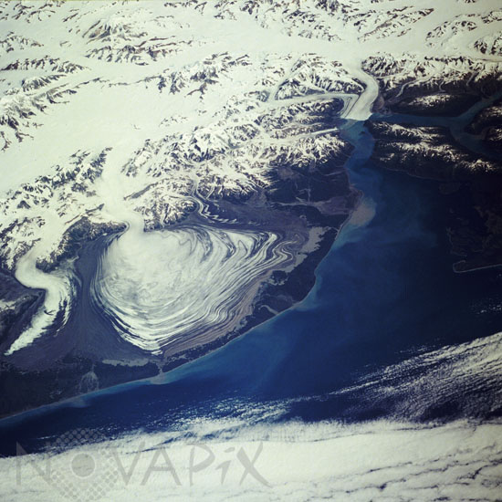
Malaspina Glacier, Alaska, U.S.A. August 1989
auteur: Nasa/USGS/Novapix
référence: t-naalk-00004
Image Size 300 DPI: 45 * 45 cm
Malaspina Glacier can be seen just left of the center of this northeast-looking, low-oblique photograph. Located in southern Alaska on the shore of the Gulf of Alaska, Malaspina Glacier is a classic example of a piedmont glacier lying at the foot of a mountain range"in this case, the Saint Elias Mountains (just north of the glacier). The glacier covers an area of 1500 square miles (3900 square kilometers) on the coastal plain, is nearly 60 miles (97 kilometers) long, and is more than 1000 feet (300 meters) thick. The Seward Ice Field is the principal source of ice for the glacier. The glacier moves in surges that push earlier-formed moraines outward into expanding concentric patterns, which you can see along the flanks of the ice mass. To the northwest of Malaspina Glacier is the curved and pointed Agassiz Glacier, which is also fed by the Seward Ice Field. To the northeast of Malaspina Glacier, located at the head of Yakutat Bay, is the Hubbard Glacier, which surged in 1989, blocking the entrance to Russell Fiord and temporarily trapping a large number of marine animals.
Keywords for this photo:
1989 - ALASKA - EARTH - EARTH FROM SPACE - GLACIER - MALASPINA GLACIER - MOUNTAIN - SNOW - STS-28 - USA - WATER -
Contact : Stéphane Aubin +33-(0)9-51-26-53-76
© Novapix - All rights reserved