
Photo Agency - Astronomy - Space - Nature


> Earth from space gallerie
 |
 |
SlideShow Image 1650 / 2740 |  |
 |
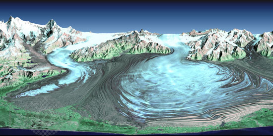
The Malaspina Glacier in Alaska
auteur: Nasa/Novapix
référence: t-naalk-00005
Image Size 300 DPI: 26 * 13 cm
Malaspina Glacier in southeastern Alaska is considered the classic example of a piedmont glacier. Piedmont glaciers occur where valley glaciers exit a mountain range onto broad lowlands, are no longer laterally confined, and spread to become wide lobes. Malaspina Glacier is actually a compound glacier, formed by the merger of several valley glaciers, the most prominent of which seen here are Agassiz Glacier (left) and Seward Glacier (right). In total, Malaspina Glacier is up to 65 kilometers (40 miles) wide and extends up to 45 kilometers (28 miles) from the mountain front nearly to the sea. This perspective view was created from a Landsat satellite image and an elevation model generated by the Shuttle Radar Topography Mission (SRTM). Landsat views both visible and infrared light, which have been combined here into a color composite that generally shows glacial ice in light blue, snow in white, vegetation in green, bare rock in grays and tans, and the ocean (foreground) in dark blue. The back (northern) edge of the data set forms a false horizon that meets a false sky. Glaciers are sensitive indicators of climatic change.
Keywords for this photo:
2000 - ALASKA - EARTH - EARTH FROM SPACE - GLACIER - LANDSAT - LANDSAT-7 - MALASPINA GLACIER - RADAR - SATELLITE IMAGE - SRTM - USA - WATER -
Contact : Stéphane Aubin +33-(0)9-51-26-53-76
© Novapix - All rights reserved