
Photo Agency - Astronomy - Space - Nature


> Earth from space gallerie
 |
 |
SlideShow Image 1638 / 2740 |  |
 |
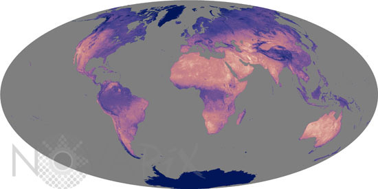
Hottest land surface temperatures between 2003 and 2005
auteur: Nasa/Novapix
référence: t-glb50-00110
Image Size 300 DPI: 30 * 15 cm
This image shows the hottest land surface temperature instrument MODIS on Aqua satellite recorded at each location on Earth between 2003 and 2005. The hottest places, shown in light pink, are barren or sparsely vegetated deserts. These areas dominate northern Africa, southern Asia, Australia, and parts of western North and South America. Densely vegetated areas such as the Amazon and Congo rain forests of South America and Africa and the boreal forests of North America and Eurasia are much cooler, showing up as purple. Cooler yet, in blue, are high elevations like the Tibetan Plateau and mountain ranges. The coldest locations are the ice-capped lands near the North and South Poles. According to MODIS, the hottest place in 2004 and 2005 was the Lut desert of Iran, which reached 70.7 degrees C (159 degrees F). In 2003, Queensland, Australia, was the hottest place on Earth, with a temperature of 69.3 degrees C (157 degrees F).
Keywords for this photo:
AQUA - CLIMATE - EARTH - EARTH FROM SPACE - GLOBAL VIEW - MODIS - PLANET - PLANISPHERE - SATELLITE IMAGE - SOIL - TEMPERATURE -
Contact : Stéphane Aubin +33-(0)9-51-26-53-76
© Novapix - All rights reserved