
Photo Agency - Astronomy - Space - Nature


> Earth from space gallerie
 |
 |
SlideShow Image 1563 / 2740 |  |
 |
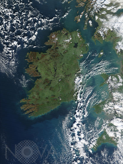
Ireland satellite view
auteur: Nasa/GSFC/Novapix
référence: t-euirl-00002
Image Size 300 DPI: 20 * 27 cm
True-color Moderate Resolution Imaging Spectroradiometer (MODIS) image of Ireland taken from Terra satellite on January 4, 2003. The rugged cliffs that mark the island's west coast are showing their red-brown rocky surface, but the low-lying interior region is still wearing the island's signature green. The highest elevation in Ireland is Carrantuohill, located in the rugged terrain of the southwest tip. The bowl-like shape creates the network of lakes scattered across the island, and over time has produced peat bogs, which provide a source of fuel on the island, which is covered mostly by pasture and meadows. Ireland's largest city, Dublin, makes a purplish-gray patch peeking out from the clouds about halfway down the east coast. Belfast is more clearly visible on the coast in the northeast, due east of large Lake Neagh. One Ireland's few other large cities, Cork, is located at the mouth of the Lee River, at the mid-point of the southern shoreline.
Keywords for this photo:
2003 - EARTH - EARTH FROM SPACE - EUROPE - IRELAND - ISLAND - MODIS - NORTHERN IRELAND - SATELLITE IMAGE - TERRA -
Contact : Stéphane Aubin +33-(0)9-51-26-53-76
© Novapix - All rights reserved