
Photo Agency - Astronomy - Space - Nature


> Earth from space gallerie
 |
 |
SlideShow Image 1554 / 2740 |  |
 |
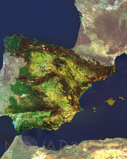
Spain seen from satellite
auteur: Esa/Novapix
référence: t-euesp-00002
Image Size 300 DPI: 38 * 48 cm
This Mosaic Full Resolution Imaging Spectrometer (MERIS) image shows the Kingdom of Spain, located in the southwest of Europe. Spain is bound to the east by Mediterranean Sea (containing the Balearic Islands), to the north by the Bay of Biscay and to its west by the Atlantic Ocean, where the Canary Islands off the African coast are found. Satellite Envisat
Keywords for this photo:
BALEARIC ISLANDS - EARTH - EARTH FROM SPACE - ENVISAT - EUROPE - ISLAND - MEDITERRANEAN SEA - MERIS - SATELLITE IMAGE - SEA - SPAIN -
Contact : Stéphane Aubin +33-(0)9-51-26-53-76
© Novapix - All rights reserved