
Photo Agency - Astronomy - Space - Nature


> Earth from space gallerie
 |
 |
SlideShow Image 1468 / 2740 |  |
 |
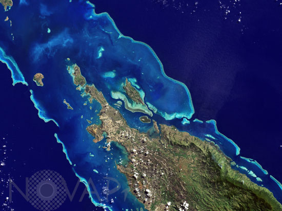
Grande Terre, New Caledonia, seen from space
auteur: Nasa/USGS/Novapix
référence: t-ocnca-00002
Image Size 300 DPI: 33 * 25 cm
In July 2008, UNESCO added 27 new areas to its list of World Heritage sites. One of those areas included the lagoons of New Caledonia. Some 1,200 kilometers (750 miles) east of Australia, this French-governed archipelago contains the world's third-largest coral reef structure. The coral reefs enclose the waters near the islands in shallow lagoons of impressive biodiversity. On May 10, 2001, the Enhanced Thematic Mapper Plus on NASA's Landsat 7 satellite captured this image of Ile Balabio, off the northern tip of Grande Terra, New Caledonia's main island. In this natural-color image, the islands appear in shades of green and brown"mixtures of vegetation and bare ground. The surrounding waters range in color from pale aquamarine to deep blue, and the color differences result from varying depths. Over coral reef ridges and sand bars, the water is shallowest and palest in color. Darker shades of blue characterize deeper waters. Reef-enclosed, shallow waters surround Ile Balabio, and a larger, semi-enclosed lagoon appears immediately east of that island. Immediately north of Grande Terra, unenclosed, deeper waters predominate.
Contact : Stéphane Aubin +33-(0)9-51-26-53-76
© Novapix - All rights reserved