
Photo Agency - Astronomy - Space - Nature


> Earth from space gallerie
 |
 |
SlideShow Image 1451 / 2740 |  |
 |
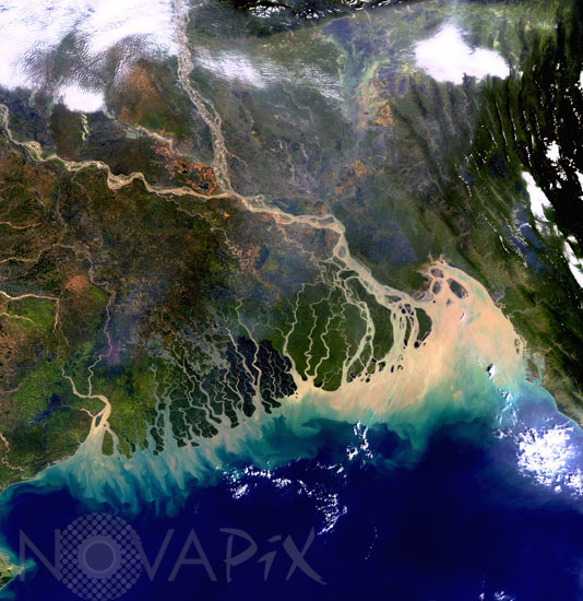
Ganges delta as seen from Envisat
auteur: ESA/Novapix
référence: t-asban-00003
Image Size 300 DPI: 17 * 17 cm
This image taken by european satellite Envisat covers all of the Bangladesh coast as well as some of India on its western side and Myanmar (Burma) on the eastern side. Most of Bangladesh lies within the broad delta formed by the Ganges River (flowing from the west) and the Brahmaputra River (flowing from the north). The Ganges is the most important river of the Indian subcontinent. It flows through Bangladesh into the Bay of Bengal in the Indian Ocean. Several distributaries form a vast network of waterways and one of the world's largest, most fertile deltas. Because the discharge includes large deposits of sediments - as can be seen in the brown colour in the image - the delta continues to expand into the Bay. This country, flat and low-lying is subject to annual flooding. This Medium Resolution Imaging Spectrometer (MERIS) image was acquired on 8 November 2003. The image was acquired in Full Resolution mode, providing a spatial resolution of 300 metres and covering approximately 633 km by 630 km.
Keywords for this photo:
2003 - ASIA - BANGLADESH - DELTA - EARTH - EARTH FROM SPACE - ENVISAT - GANGES - GANGES DELTA - INDIA - RIVER - SATELLITE IMAGE - WATER -
Contact : Stéphane Aubin +33-(0)9-51-26-53-76
© Novapix - All rights reserved