
Photo Agency - Astronomy - Space - Nature


> Earth from space gallerie
 |
 |
SlideShow Image 1421 / 2740 |  |
 |
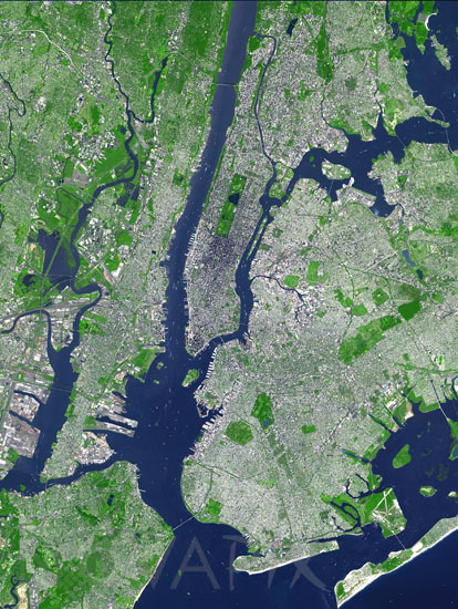
New York City seen from space
auteur: Nasa/GSFC/Novapix
référence: t-nanyc-00007
Image Size 300 DPI: 16 * 22 cm
This image taken by satellite Terra shows New York City and the Island of Manhattan, bordered by the Hudson and East Rivers. Parts of Long Island and Staten Island are also visible. Two of New York's major airports (Newark and La Guardia) are within the image. In the middle of Manhattan, Central Park appears as a long green rectangle with a large lake in the middle. The image covers an area of 27 x 37 km, and was acquired September 8, 2002, and is located at 40.7 degrees north latitude and 74 degrees west longitude .
Keywords for this photo:
2002 - CITY - EARTH - EARTH FROM SPACE - HUDSON - ISLAND - NEW YORK - NEW YORK CITY - NYC - RIVER - SATELLITE IMAGE - TERRA - USA -
Contact : Stéphane Aubin +33-(0)9-51-26-53-76
© Novapix - All rights reserved