
Photo Agency - Astronomy - Space - Nature


> Earth from space gallerie
 |
 |
SlideShow Image 1396 / 2740 |  |
 |
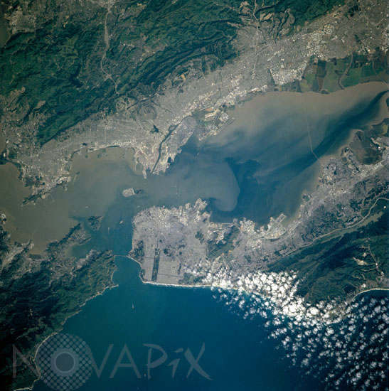
San Francisco Bay area seen from space
auteur: Nasa/Novapix
référence: t-nacal-00007
Image Size 300 DPI: 34 * 34 cm
San Francisco Bay Area, California April 17, 1998.
Considered one of the best natural harbors in the world, San Francisco Bay, with its various sediment patterns, can be seen in this unique near-vertical view. Surrounded by the San Francisco Metropolitan area to the west and southwest, the Berkeley and Oakland Metropolitan area to the east, and the San Jose Metropolitan (not visible on the image) to the southeast, San Francisco Bay is 50 miles (80 km) long and from 3 to 13 miles (5 to 21 km) wide. Waters of the Pacific Ocean (bottom of image) enter the bay through Golden Gate, a strait between two peninsulas. The world famous Golden Gate Bridge is discernible on the image connecting the two peninsulas. The bay is as deep as 100 feet (30 meters) in spots, with a channel 50 feet (15 meters) deep maintained through the sand bar off Golden Gate. The major transportation routes in all metropolitan areas are visible on this image. Also discernible is the San Mateo Bridge near the right center of the image. Just to the left of the center of the image is Treasure Island, an artificial island covering 400 acres (162 hectares). It was constructed as a site of the Golden Gate International Exposition (1939-1940) and became a United States Naval Base in 1941. The small white objects in the bay and entering the golden gate are ships.
Considered one of the best natural harbors in the world, San Francisco Bay, with its various sediment patterns, can be seen in this unique near-vertical view. Surrounded by the San Francisco Metropolitan area to the west and southwest, the Berkeley and Oakland Metropolitan area to the east, and the San Jose Metropolitan (not visible on the image) to the southeast, San Francisco Bay is 50 miles (80 km) long and from 3 to 13 miles (5 to 21 km) wide. Waters of the Pacific Ocean (bottom of image) enter the bay through Golden Gate, a strait between two peninsulas. The world famous Golden Gate Bridge is discernible on the image connecting the two peninsulas. The bay is as deep as 100 feet (30 meters) in spots, with a channel 50 feet (15 meters) deep maintained through the sand bar off Golden Gate. The major transportation routes in all metropolitan areas are visible on this image. Also discernible is the San Mateo Bridge near the right center of the image. Just to the left of the center of the image is Treasure Island, an artificial island covering 400 acres (162 hectares). It was constructed as a site of the Golden Gate International Exposition (1939-1940) and became a United States Naval Base in 1941. The small white objects in the bay and entering the golden gate are ships.
Keywords for this photo:
1998 - BAY - CALIFORNIA - CITY - EARTH - EARTH FROM SPACE - PACIFIC OCEAN - SAN FRANCISCO - STREAM - STS-90 - USA -
Contact : Stéphane Aubin +33-(0)9-51-26-53-76
© Novapix - All rights reserved