
Photo Agency - Astronomy - Space - Nature


> Earth from space gallerie
 |
 |
SlideShow Image 1323 / 2740 |  |
 |
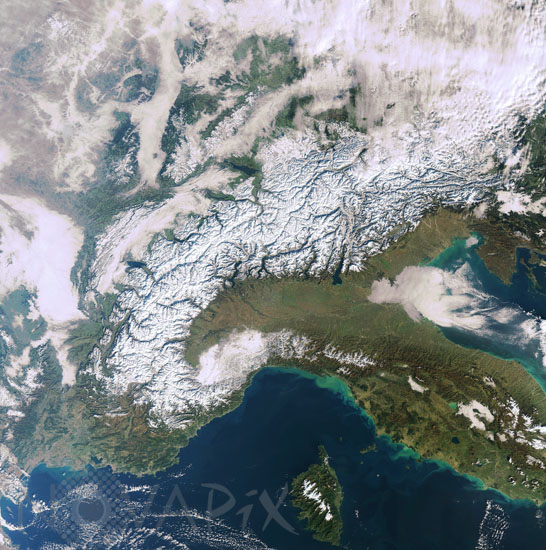
The Alps as seen from satellite Envisat
auteur: ESA/Novapix
référence: t-eufra-00036
Image Size 300 DPI: 28 * 28 cm
The snow-capped, crescent-shaped Alps and Italyâs Apennines mountain chain are shown in this Envisat image. Snowfall in early winter â for meteorologists winter begins on the 1 December â covered the whole mountain areas with fresh snow, while the lower lands in the south and north of the mountains remained snow-free. Due to this snow cover and a relatively low illumination angle of the sun, the ranges and valleys of the mountains stand out in the image. Much of the whiteness seen in the top of the image is cloud cover, but fog is visible in the valleys such as the Rhine.
The Alps â central Europeâs major mountain range â extend some 1 200 km through France, Switzerland, Italy and Austria and down through Slovenia, Croatia, Bosnia and Herzegovina, Serbia and Montenegro and Albania as the Dinaric Alps. The Alps occupy an area of about 200 000 km² and are inhabited by some 20 million people. On the southern side of the Alps a series of glacier carved lakes are visible in dark blue, including Lake Como, Lake Maggiore and Lake Garda. With an area of 370 km², Garda is the largest lake in Italy. The Apennines (visible mostly in brown) stretch the entire length of the Italian Peninsula. Most of Italyâs rivers find their source in the Apennines, including the Tiber and Arno. Lakes visible on the Italian Peninsula include Trasimeno (green) and Bolsena (blue). All lakes of central Italy are of volcanic origin and are resting in former volcano craters, which accounts for their almost perfectly round shape. The Ligurian Sea to the west of Italy and the Adriatic Sea to Italyâs east are both visible. (In this image, north is in the upper left corner.) The light green colour of the seas along the coast is caused by increased sediments carried by the rivers due to the heavy rainfalls over the last weeks. Corsica, the Mediterraneanâs fourth largest island, is visible to the west of Italy. Snow highlights the mountain ranges that dominate the island. This image was acquired by Envisat's Medium Resolution Imaging Spectrometer (MERIS) instrument on 8 December 2008.
The Alps â central Europeâs major mountain range â extend some 1 200 km through France, Switzerland, Italy and Austria and down through Slovenia, Croatia, Bosnia and Herzegovina, Serbia and Montenegro and Albania as the Dinaric Alps. The Alps occupy an area of about 200 000 km² and are inhabited by some 20 million people. On the southern side of the Alps a series of glacier carved lakes are visible in dark blue, including Lake Como, Lake Maggiore and Lake Garda. With an area of 370 km², Garda is the largest lake in Italy. The Apennines (visible mostly in brown) stretch the entire length of the Italian Peninsula. Most of Italyâs rivers find their source in the Apennines, including the Tiber and Arno. Lakes visible on the Italian Peninsula include Trasimeno (green) and Bolsena (blue). All lakes of central Italy are of volcanic origin and are resting in former volcano craters, which accounts for their almost perfectly round shape. The Ligurian Sea to the west of Italy and the Adriatic Sea to Italyâs east are both visible. (In this image, north is in the upper left corner.) The light green colour of the seas along the coast is caused by increased sediments carried by the rivers due to the heavy rainfalls over the last weeks. Corsica, the Mediterraneanâs fourth largest island, is visible to the west of Italy. Snow highlights the mountain ranges that dominate the island. This image was acquired by Envisat's Medium Resolution Imaging Spectrometer (MERIS) instrument on 8 December 2008.
Keywords for this photo:
2008 - ALPS - AUSTRIA - CORSICA - EARTH - EARTH FROM SPACE - ENVISAT - EUROPE - FRANCE - ITALY - MEDITERRANEAN SEA - MERIS - MOUNTAIN - SATELLITE IMAGE - SNOW - SWITZERLAND -
Contact : Stéphane Aubin +33-(0)9-51-26-53-76
© Novapix - All rights reserved