
Photo Agency - Astronomy - Space - Nature


> Earth from space gallerie
 |
 |
SlideShow Image 1387 / 2740 |  |
 |
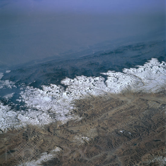
Himalaya Mountains, Nepal March 1996
auteur: Nasa/Novapix
référence: t-asnep-00010
Image Size 300 DPI: 34 * 34 cm
The Himalaya Mountains provide a formidable physical barrier between the hazy environmental conditions of north central India (top) and Nepal (middle), and the clear atmosphere of the Tibetan Plateau (lower third of image). Elevation disparities in this region of the world are tremendous. For example the elevations on the Gangetic Plain in India averages about 300 feet (92 meters) above sea level, the foothills (dark-looking features that run laterally across the image) in Nepal average about 2500 feet (762 meters), and finally the snow capped Himalayas average around 24000 feet (7315 meters). Mt. Everest, highest mountain peak in the world at 29028 feet (8848 meters), is visible as an identifiable bright feature (slightly below and left of center). Several east-west aligned fault valleys (result of tectonic forces-collision of plate boundaries) are visible on the sparsely vegetated Tibetan Plateau (China) where the average valley elevation is 15000 feet (4572 meters) above sea level. A small section of the easterly draining Brahmaputra River can be discerned near the lower right corner of the image.
Keywords for this photo:
1996 - ASIA - EARTH - EARTH FROM SPACE - EVEREST - HAZE - HIMALAYAS - INDIA - MOUNT EVEREST - MOUNTAIN - NEPAL - PLATEAU - SNOW - STS-76 - TIBET -
Contact : Stéphane Aubin +33-(0)9-51-26-53-76
© Novapix - All rights reserved